Due to the number of people looking for Condominium and Townhouses, changes have been made to the listings search criteria. "Residential" is now split into "Houses", "Condominiums/Townhouses", and "Manufactured Homes".
Please post your thoughts and comments. Include any other search criteria you would like to see.
Tuesday, December 18, 2007
Monday, December 17, 2007
Google Earth Imagery Updated
As mentioned in Google Earth Blog, Google updated quite a bit of imagery in December. I can report that this includes the area around Kuna, Idaho. Boise was updated over the summer, so it looks like we are rather current. Please add a comment if you know of other areas in Ada and Canyon counties that have been updated.
Tuesday, November 6, 2007
Earth Point for Your Town or Company
Several people have asked if Earth Point is available for other cities or projects. Like a new house, the answer is yes, we can build it. The following elements are needed for a presentation on Google Earth.
- Good satellite imagery. For most urban areas, the imagery is excellent.
- Digital mapping files of legal parcels. These are used to accurately locate properties on Google Earth. Digital mapping files are generally available from the local county assessor’s office, in the form of ESRI shape files. The cost varies greatly, anywhere from free to thousands of dollars.
- Access to local MLS data. This is accomplished by either by joining the MLS organization or by forming a partnership with a current member.
- A revenue model. Earth Point can capably take care of steps one through three. We need someone local to take care of step four. It would take about a month to map the county assessor data onto Google Earth. It would take perhaps two more months to include the MLS data. From there, it would be good to budget time for keeping it current and for a regular stream of enhancements.
With over 20-million records in its database and a fast presentation speed, Earth Point ably manages large ESRI shape files, robust databases, the web environment, and Google Earth. Earth Point can map fixed and mobile assets, turning Google Earth into an information manager for almost any system. Please call if Earth Point can assist with any of your IT or data processing needs.
Phone 208.860.6311 or email bill.clark@earthpoint.us.
Earth Point real estate software is protected by copyright. Local implementations are licensed to the client.
Monday, September 10, 2007
Quarter Sections available with BLM data
Quarter sections are now included with the BLM Township and Range data. Due to the sheer number of quarter sections (over 17 million), Earth Point did not included these previously.
How it works.
Zoom in on a Township, see Sections.
Zoom in on a Section, see Quarters.
How it works.
- Earth Point gets it data from BLM shape files available at http://www.geocommunicator.gov/GeoComm/lsis_home/home/index.html
- Earth Point formats the data, stores it in a database, and manages the interaction with Google Earth.
Note: I have spot-checked the data, but I have not checked all 17 million records! If you find an inconsistency, please let me know.
View the Township and Range Data on Google Earth.
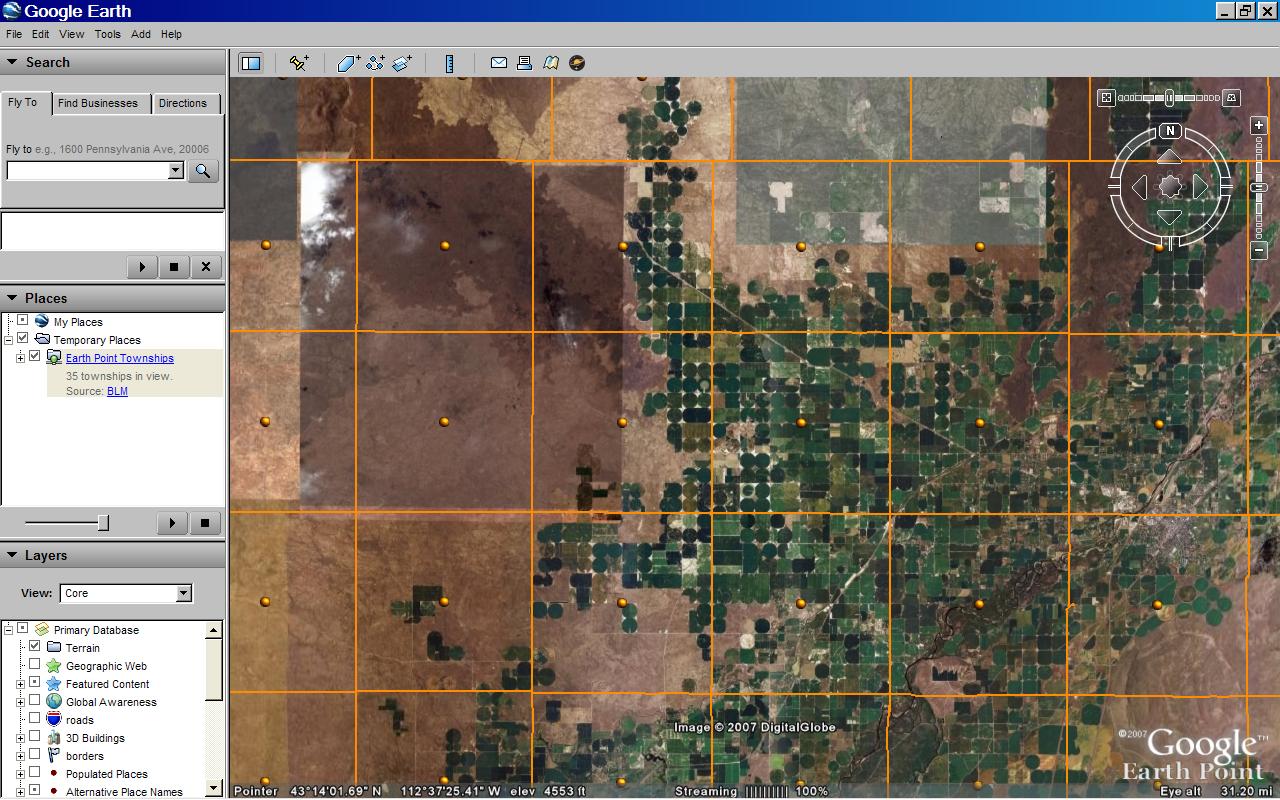
- Open Google Earth. Zoom into an area of interest over the western United States. The picture below is near Blackfoot, Idaho. It was selected because irrigated crop circles, which follow the pattern of land ownership, are generally laid out within the boundaries of quarter sections.
- Go to www.earthpoint.us/Townships.aspx.
- Scroll down to "BLM Township, Range, and Section."
- Click the "View on Google Earth" button.
- The screen switches back to Google Earth.
- The orange grid shows the BLM Townships, which are six miles square.
BLM Townships on Google Earth. Click for larger image.
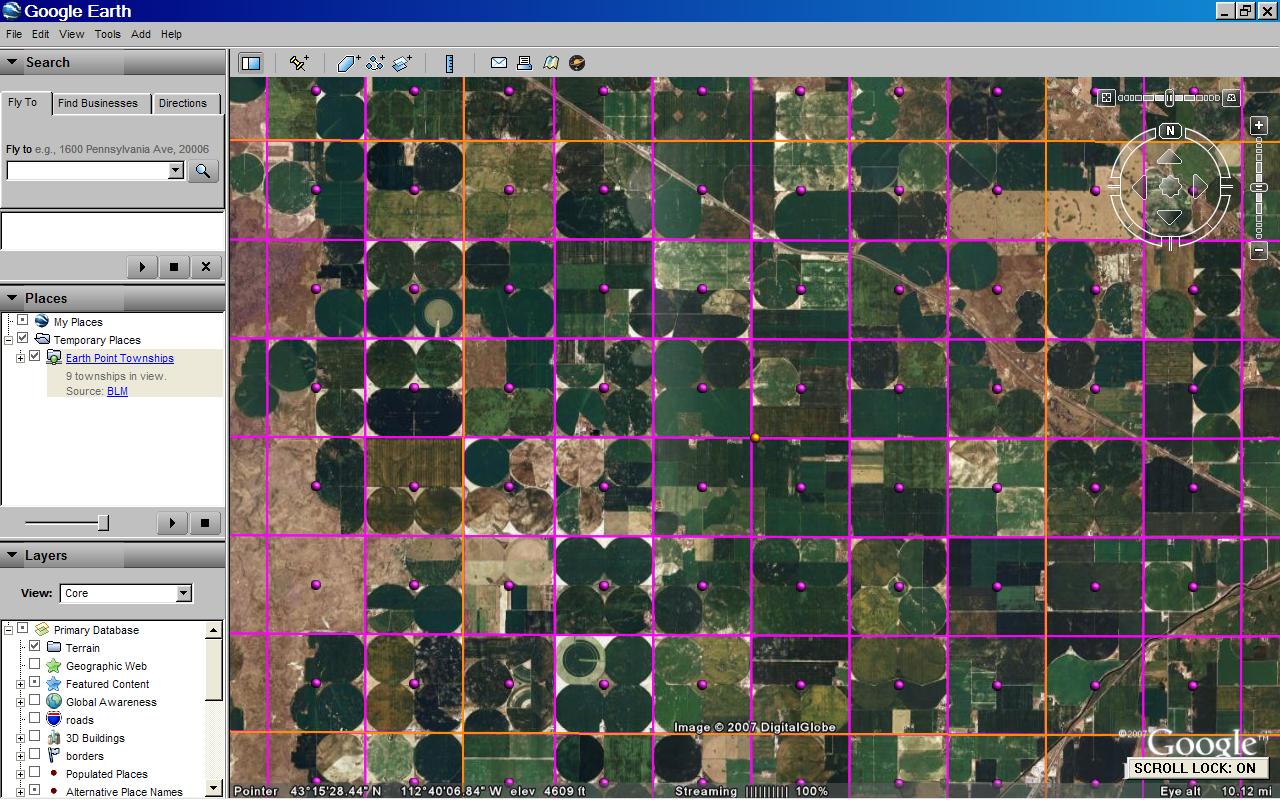
Zoom in on a Township, see Sections.
- Double-click an orange dot. This zooms you in closer.
- After a few seconds, the township is divided up into purple squares. These are Sections, which are one-mile square.
BLM Sections on Google Earth. Click for larger image.
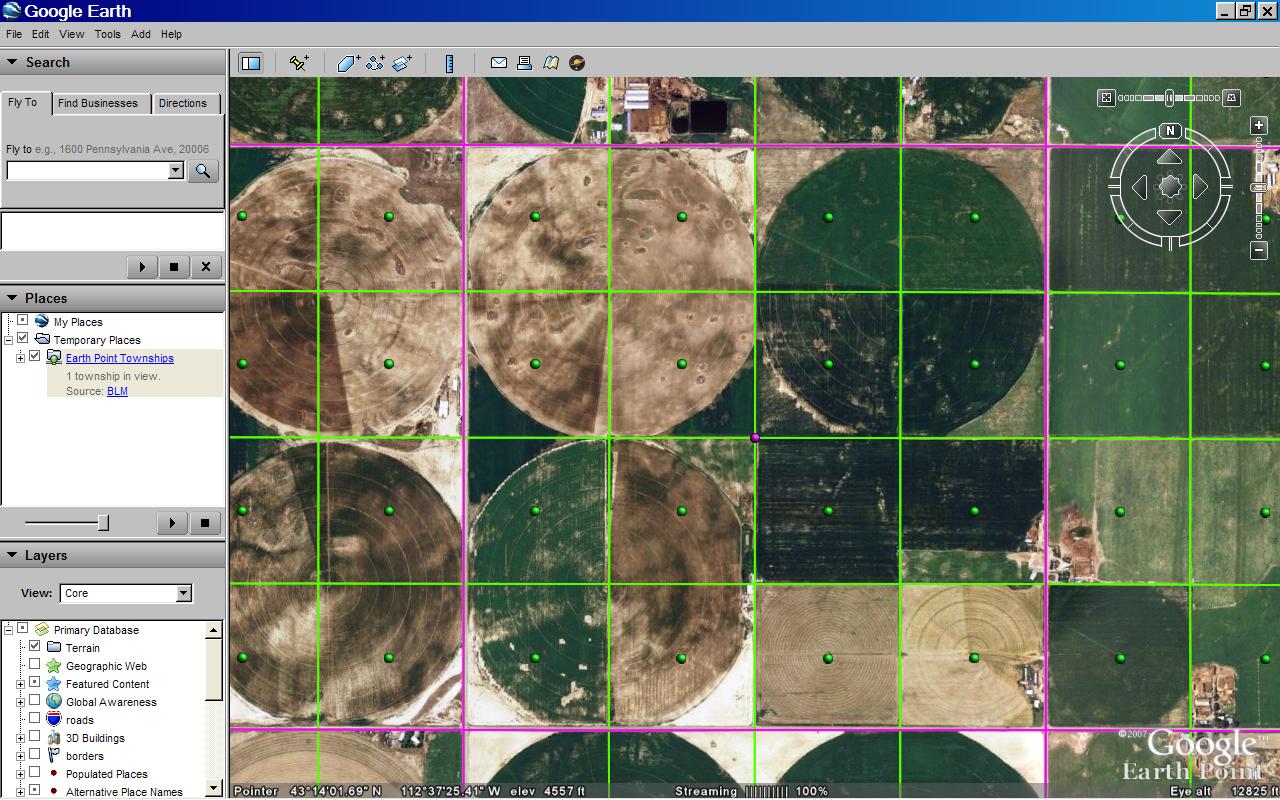
Zoom in on a Section, see Quarters.
- Double-click a purple dot. This zooms you in closer.
- After a few seconds, the section divided up into green squares. Depending on the survey, these will be Quarter sections (1/2 mile square), Quarter/Quarter sections (1/4 mile square), or similar. The picture below shows Quarter/Quarter sections.
BLM Quarter/Quarters on Google Earth. Click for larger image.
Tuesday, May 15, 2007
Township and Range
A few months ago I was asked if I could overlay a parcel map onto Google Earth. The property was in a rural area south of San Francisco. Since I am not familiar with the area, it took an hour and numerous Google searches to get an idea of where map should be located.
However, now that Township and Range is available on Google Earth, the process only takes a few minutes.
You can see the result below, or download the corresponding kmz file.
Thanks to Nick Wold of Orbit Investments for suggesting that BLM townships be mapped onto Google Earth.
How to position a plat map onto Google Earth.
If the map is of an area that has BLM coverage and if you have a rough idea about its location, then you could possibly take this shortcut.
However, now that Township and Range is available on Google Earth, the process only takes a few minutes.
You can see the result below, or download the corresponding kmz file.
Plat map overlaid on Google Earth. Shown with BLM section lines. Click for larger image.
Thanks to Nick Wold of Orbit Investments for suggesting that BLM townships be mapped onto Google Earth.
How to position a plat map onto Google Earth.
If the map is of an area that has BLM coverage and if you have a rough idea about its location, then you could possibly take this shortcut.
- Zoom into the area on Google Earth.
- Go to the Earth Point Township & Range page.
- Under "BLM Townships, Ranges, and Sections" click the "View on Google Earth" button.
- Once the Townships and Sections appear on Google Earth, mouse-over the purple icons and find the section you are looking for.
- Then go directly to the Put the map onto Google Earth section below.
Otherwise, start at the beginning...
We need to know which state and which prime meridian the map is part of.
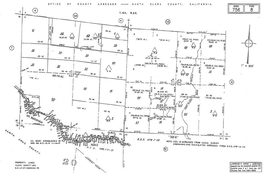
Plat map. Click for larger image.
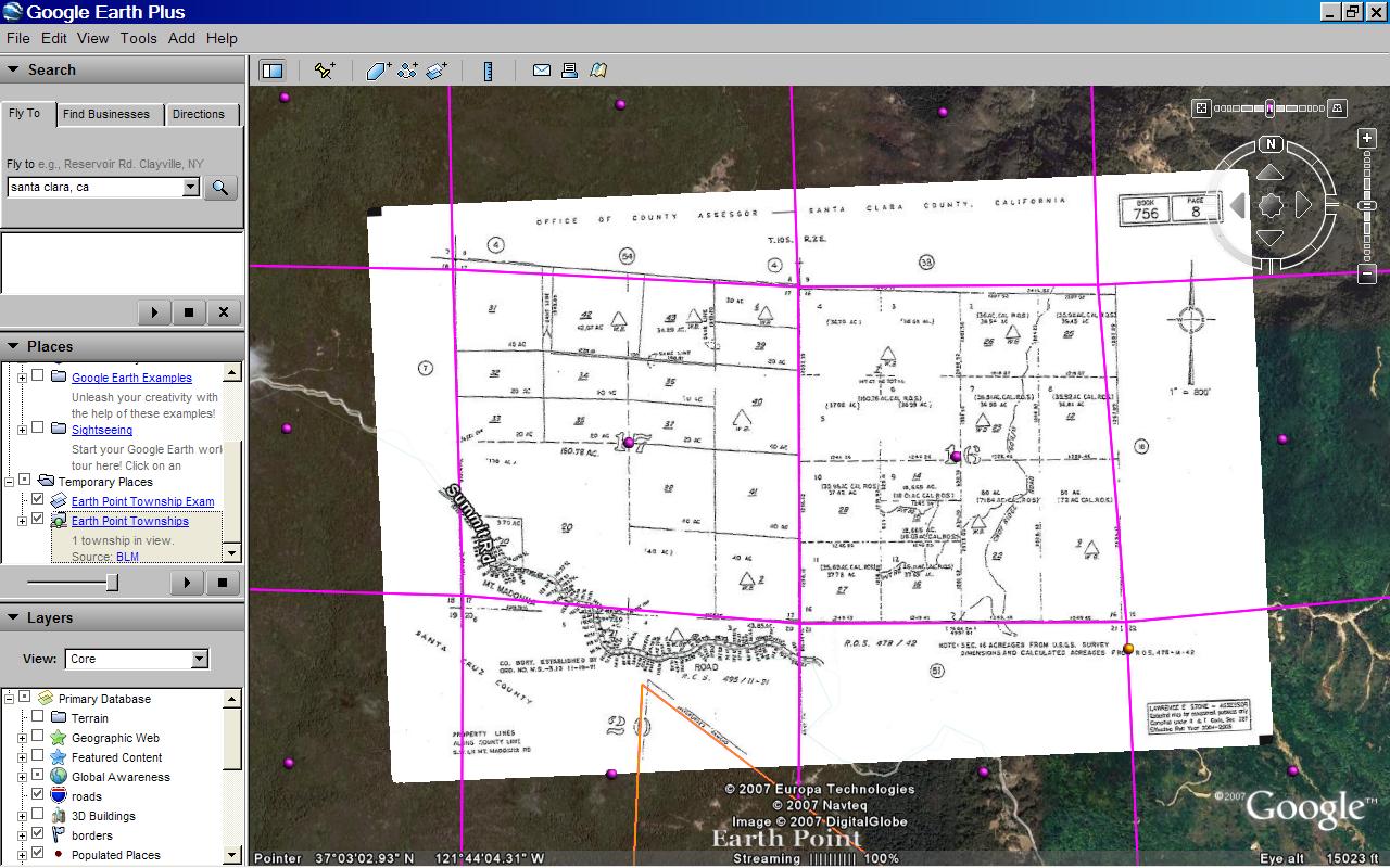
- Click on the plat map above to see it full size. At the top of the image we see that it is part of T10S R2E (Township 10 South, Range 2 East) in Santa Clara County, California. The map itself covers sections 16 and 17.
- California has three principal meridians. The next few steps show one way to figure out which one to use.
- Go to the Google Earth "Fly To" box and type in "Santa Clara, California". The city of Santa Clara is located in Santa Clara County, so now we are in the neighborhood.
- Go to Earth Point's Township & Range page.
- In the "National Atlas" section, click the "View On Google Earth" button. "National Atlas" is used because it has the best coverage.
- The Google Earth screen fills with township outlines.
- Mouse-over the yellow icons. You will see that these townships originate from the "Mount Diablo" principal meridian.
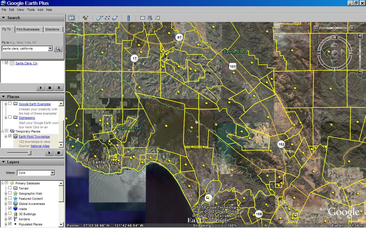 "National Atlas" townships. Centered on T10S R2E, Santa Clara County. Click for larger image.
 - At this point, you could look for T10S R2E, but this is harder than it seems. Much of California's land survey is based on original land grants and is not laid out in a nice grid. Therefore, we will use Earth Point's "Fly To" button to locate the township.
- To keep the Google Earth screen from becoming too cluttered, let's delete the townships we already have. In the Google Earth "My Places" section, right click on "Earth Point Townships ... National Atlas". On the pop-up menu, click "Delete".
- Go to the Township & Range page. In the drop-down boxes, select "California", "Mount Diablo", "10S", and "2E".
- Click the "Fly To On Google Earth" button.
- T10S R2E is displayed on the Google Earth screen.
- To position the plat map, we also need section lines.
- Go to the Township & Range page.
- Under "BLM Townships, Ranges, and Sections", click the "View On Google Earth" button.
- The BLM townships are displayed on Google Earth. If you zoom in close enough, the sections are also displayed.
- Mouse-over the purple dots to find sections 16 and 17. We could stop here, but let's place the map onto Google Earth.
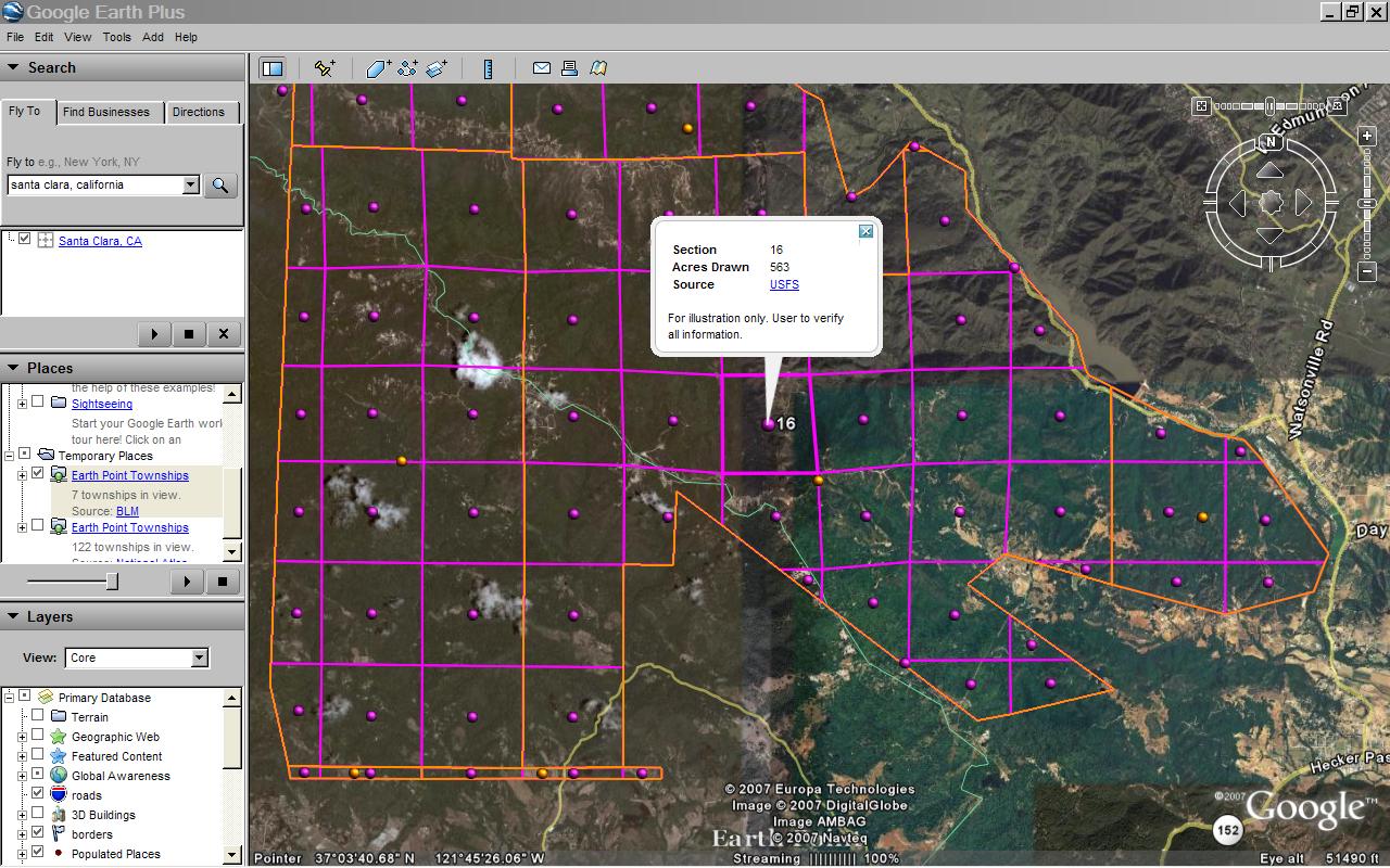 "BLM" townships, T10S R2E Section 16. Click for larger image.
- Normally, we get plat maps from a county assessor's office, title company, or the like.
- For this example, we can use the map above.
- Scroll up to the picture captioned Plat map. Click for larger image. Right-click the map. Click "Save As" on the pop-up menu.
- We are going to make an image overlay. The Google Earth User Guide has more information about image overlays.
- On the Google Earth menu at the top of the screen, click "Add" then "Image Overlay".
- On the window that pops-up, click the "Browse" button and get the plat map you saved.
- Shrink, stretch, and rotate the plat map to fit BLM sections 16 and 17 as best you can. It will not be perfect.
- Adjust the transparency so that you can see both the dark lines on the plat map and features on the underlying Google Earth imagery.
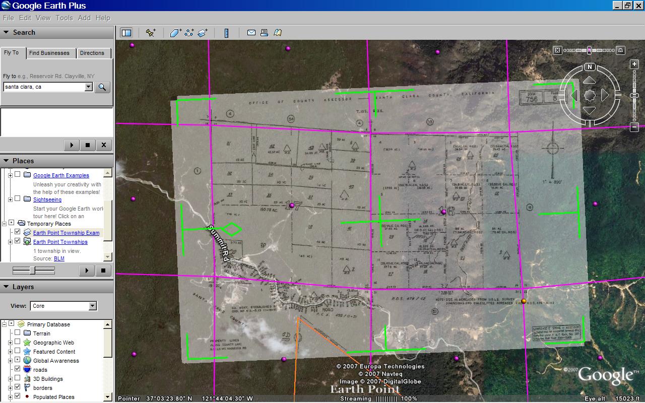 Plat map aligned with Google Earth. Transparency is set to show the underlying satellite imagery. Transparency will be removed before the image overlay is saved. Click for larger image.
 - Shrink, stretch, and rotate the plat map again, this time to fit the Google Earth imagery.
- Remove the transparency.
- Add a comment or two and save the image overlay.
- That's it!
Thursday, February 1, 2007
Virtual Tours
Virtual tours are a great way to market a home. With 360-degree panoramas, additional pictures, and even room planners it is easy to see why virtual tours are so popular.
Each listing in our MLS can link to a virtual tour. Earth Point displays this link provided that it points to a known tour company.
Another requirement is that the tour company must offer a non-branded version of the tour. Branded tours promote a real estate company and its agents. Non-branded tours promote just the property. Earth Point always displays the non-branded tour, even if a branded link is entered into the MLS system.
The number of virtual tour companies is ever growing. If your listing uses a company that is not shown here, please let me know.
Virtual Tour Companies Known to Earth Point
360House
InTouch Home Tours
Just Snooping
Obeo
Real Estate Shows
Real Tour Vision
Tour Factory
Tour Real Estate
Vi360
Visual Tour
Windermere
Monday, January 29, 2007
Floor Plans on Google Earth
Recently, an out of town customer was was interested in City Side Lofts, a condominium project in downtown Boise. One challenge was that it was difficult to communicate how the units are laid out, which way the windows face, and what the different views might be. Our solution was to superimpose the floor plans onto Google Earth.
Click here to download the result. Once opened in Google Earth, click and unclick the various folders to see the floor plan for each level.
Combine this with the web cam, and you have a good idea of how the building is put together.
If you have a similar request, I am happy to help!
Click here to download the result. Once opened in Google Earth, click and unclick the various folders to see the floor plan for each level.
Combine this with the web cam, and you have a good idea of how the building is put together.
If you have a similar request, I am happy to help!
Sunday, January 28, 2007
Touring Homes with Earth Point
When working with clients, I use MS Word or NotePad to keep lists of the MLS numbers we have looked at or are interested in.
To organize the lists, I put a short description at the beginning of each line. The MLS numbers follow, separated by commas. Like this:
Jan 12 looked at: 98280903, 98277414, 98281328
Jan 22 preparation: 98283878, 98280321, 98284890, 98259765
From there it is a simple matter to display the listings on Google Earth. I "copy" a row of MLS Numbers into the clipboard and "paste" it into the MLS Number(s) field on the Earth Point home page.
Download to Google Earth, and there are the listings. I can even take my laptop on tour and use Google Earth to navigate from house to house. Of course, someone else has to drive!
Saturday, January 20, 2007
"Year Built" added to search critera
"Year Built" was added at the request of one of our users. Thanks for the input!
Thursday, January 18, 2007
Updated Mapping Files
The county mapping files have been updated, which means that the newest addresses and subdivisions can be mapped onto Google Earth. Earth Point gets new mapping data every few months. For the current set, Ada County data was published December 28, 2006. Canyon County data was published January 11, 2007.
Tuesday, January 9, 2007
Two web cams added
City Side Lofts and Royal Plaza are condominiums under construction in downtown Boise. You can download Boise and Caldwell area web cams from the Around Town page.
Subscribe to:
Posts (Atom)