Wednesday, December 24, 2008

Township and Range Latitude/Longitude conversions

The latitude and longitude conversions at www.earthpoint.us/townships.aspx now include both Townships and Sections. You can convert from Township and Section to Latitude and Longitude, or go the other way, from Latitude and Longitude to Township and Section. The illustration below shows the conversion from Latitude and Longitude to Township and Section.


Click for larger image.


Tuesday, December 16, 2008

A few ideas for 2009

  1. Expand the use of Earth Point in the Boise, Idaho market. Team up with a local Realtor®. Promote Earth Point in the local media.
  2. Allow the user to save their search criteria for real estate listings. Email an alert whenever a listing is added to the list.
  3. Create a "favorites" page for real estate listings. Allow the user to add lisitngs to one or more favorites lists. Map the lists to Google Earth. Email an alert to the user anytime the price or characteristics of a listing changes.
  4. Add instructional videos demonstrating the use of Earth Point.
  5. Move higher in the search rankings by providing good content. Currently, Earth Point is number 80 in a Google search for Boise Real Estate, number 10 for Google Earth Real Estate, and number one in Google searches for Township and Range and Excel To Kml.

If you have more ideas for making Earth Point a better web site, please add a comment.

Friday, December 5, 2008

Township and Range Has Corner Points


Corner points are calculated for each Township, Section, and Quarter-Section using the coordinate data provided by BLM. These values are estimates only.

Earth Point gets its data from ESRI shapefiles supplied by BLM. Each Township/Range/Quarter polygon can have anywhere from eight to fifty or more points defining its perimeter. For each point, Earth Point calculates the interior angle and the orientation of that angle. If the angle is close to 90°, faces in the right direction, and is close a corner point of shape's bounding box, then the point is considered to be a corner point of the polygon itself. If a polygon is irregularly shaped, then it might not have all four corner points.

Friday, February 8, 2008

Excel To Kml - Direction Arrows for GPS Track

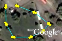
ExcelToKml can draw direction arrows on a GPS track.  The column headings to look at are "IconHeading" and "IconColor".

The picture to the right shows an example of a GPS track.  Note that the arrows point in the direction of travel.  This track was plotted with the following spreadsheet values:


  A B C D E F
1 Latitude Longitude Icon IconHeading IconColor LineColor
2 43.6097 -116.2048 196 line -180 yellow aqua
3 43.6095 -116.2047 196 line -180 yellow aqua
4 43.6094 -116.2046 196 line -180 yellow aqua
5 43.6094 -116.2044 196 line -180 yellow aqua
6 43.6094 -116.2042 196 line -180 yellow aqua
7 43.6095 -116.2041 196 line -180 yellow aqua
8 43.6096 -116.2043 196 line -180 yellow aqua
9 43.6097 -116.2046 196 line -180 yellow aqua


This spreadsheet is included in the sample data.

The column IconHeading specifies how many degrees to rotate the icon.  IconHeading can be a number, the word "line", or the word "line" plus or minus a number.

For example, Icon 222 is Google's airplane icon. It looks like this on Google Earth.

If a value of 90 is entered into the IconHeading column, the icon is rotated 90 degrees to the right.

If a value of -90 is entered into the IconHeading column, the icon is rotated 90 degrees to the left.

If the word "line" is entered into the IconHeading column, the airplane is rotated to point in the direction of travel.  That is, the airplane looks like it is flying along the line.

If the value "line-180" is entered into the IconHeading column, the airplane is lined up with the direction of travel, then spun around 180 degrees.  The airplane looks like it is flying backwards.

"line-180" is quite useful when using Icon 196, Google's arrow icon.  Notice that by default the arrow points down, not up.  If we specified a value of "line" in the IconHeading column, the arrow would point in the wrong direction.

To fix this, use a value of "line-180" (or "line+180"), which flips the arrow around 180 degrees and points it in the right direction.

Another problem is that the arrow is hard to see because it is just an outline.  Use IconColor to add color to any icon.  Yellow looks like this:

This combination of IconHeading and IconColor gives us the GPS track illustrated at the beginning of this article.