Wednesday, December 24, 2008

Township and Range Latitude/Longitude conversions

The latitude and longitude conversions at www.earthpoint.us/townships.aspx now include both Townships and Sections. You can convert from Township and Section to Latitude and Longitude, or go the other way, from Latitude and Longitude to Township and Section. The illustration below shows the conversion from Latitude and Longitude to Township and Section.


Click for larger image.


Tuesday, December 16, 2008

A few ideas for 2009

  1. Expand the use of Earth Point in the Boise, Idaho market. Team up with a local Realtor®. Promote Earth Point in the local media.
  2. Allow the user to save their search criteria for real estate listings. Email an alert whenever a listing is added to the list.
  3. Create a "favorites" page for real estate listings. Allow the user to add lisitngs to one or more favorites lists. Map the lists to Google Earth. Email an alert to the user anytime the price or characteristics of a listing changes.
  4. Add instructional videos demonstrating the use of Earth Point.
  5. Move higher in the search rankings by providing good content. Currently, Earth Point is number 80 in a Google search for Boise Real Estate, number 10 for Google Earth Real Estate, and number one in Google searches for Township and Range and Excel To Kml.

If you have more ideas for making Earth Point a better web site, please add a comment.

Friday, December 5, 2008

Township and Range Has Corner Points


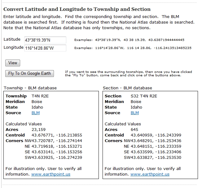
Corner points are calculated for each Township, Section, and Quarter-Section using the coordinate data provided by BLM. These values are estimates only.

Earth Point gets its data from ESRI shapefiles supplied by BLM. Each Township/Range/Quarter polygon can have anywhere from eight to fifty or more points defining its perimeter. For each point, Earth Point calculates the interior angle and the orientation of that angle. If the angle is close to 90°, faces in the right direction, and is close a corner point of shape's bounding box, then the point is considered to be a corner point of the polygon itself. If a polygon is irregularly shaped, then it might not have all four corner points.