However, now that Township and Range is available on Google Earth, the process only takes a few minutes.
You can see the result below, or download the corresponding kmz file.
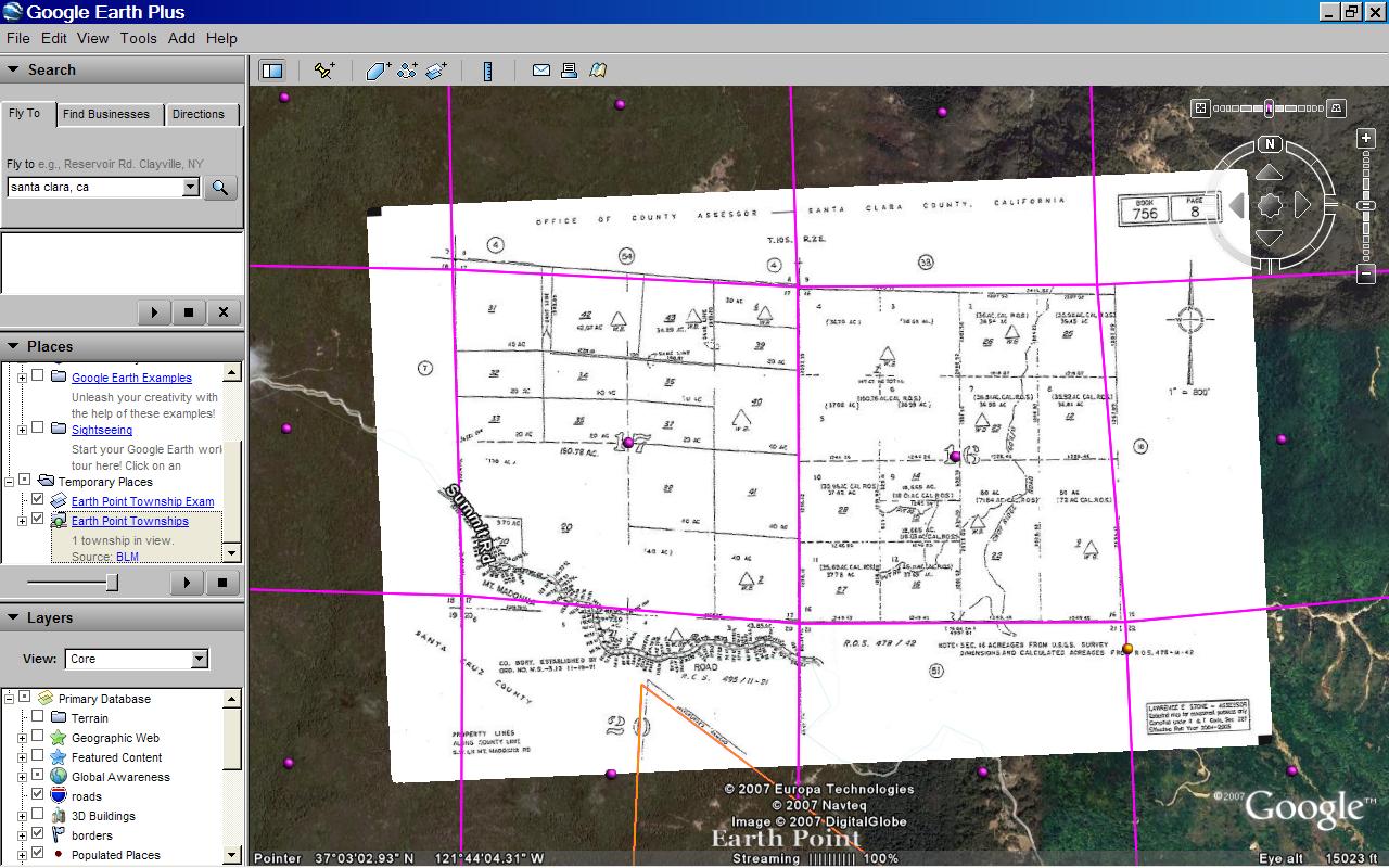
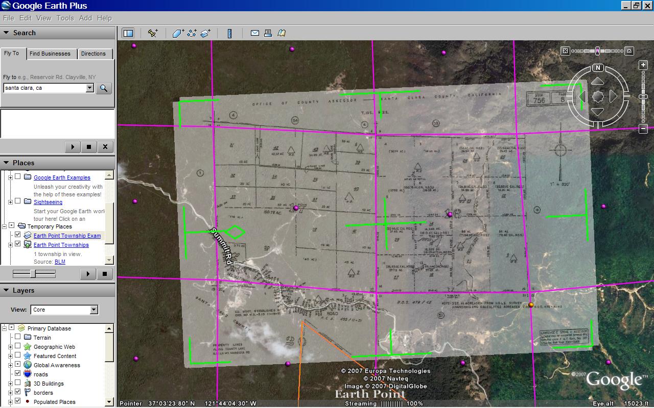
Plat map overlaid on Google Earth. Shown with BLM section lines. Click for larger image.
Thanks to Nick Wold of Orbit Investments for suggesting that BLM townships be mapped onto Google Earth.
How to position a plat map onto Google Earth.
If the map is of an area that has BLM coverage and if you have a rough idea about its location, then you could possibly take this shortcut.
- Zoom into the area on Google Earth.
- Go to the Earth Point Township & Range page.
- Under "BLM Townships, Ranges, and Sections" click the "View on Google Earth" button.
- Once the Townships and Sections appear on Google Earth, mouse-over the purple icons and find the section you are looking for.
- Then go directly to the Put the map onto Google Earth section below.
Otherwise, start at the beginning...
We need to know which state and which prime meridian the map is part of.
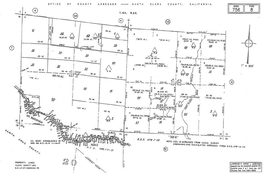
Plat map. Click for larger image.
- Click on the plat map above to see it full size. At the top of the image we see that it is part of T10S R2E (Township 10 South, Range 2 East) in Santa Clara County, California. The map itself covers sections 16 and 17.
- California has three principal meridians. The next few steps show one way to figure out which one to use.
- Go to the Google Earth "Fly To" box and type in "Santa Clara, California". The city of Santa Clara is located in Santa Clara County, so now we are in the neighborhood.
- Go to Earth Point's Township & Range page.
- In the "National Atlas" section, click the "View On Google Earth" button. "National Atlas" is used because it has the best coverage.
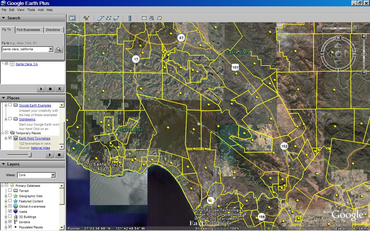
- The Google Earth screen fills with township outlines.
- Mouse-over the yellow icons. You will see that these townships originate from the "Mount Diablo" principal meridian."National Atlas" townships. Centered on T10S R2E, Santa Clara County. Click for larger image.
- At this point, you could look for T10S R2E, but this is harder than it seems. Much of California's land survey is based on original land grants and is not laid out in a nice grid. Therefore, we will use Earth Point's "Fly To" button to locate the township.
- To keep the Google Earth screen from becoming too cluttered, let's delete the townships we already have. In the Google Earth "My Places" section, right click on "Earth Point Townships ... National Atlas". On the pop-up menu, click "Delete".
- Go to the Township & Range page. In the drop-down boxes, select "California", "Mount Diablo", "10S", and "2E".
- Click the "Fly To On Google Earth" button.
- T10S R2E is displayed on the Google Earth screen.
- To position the plat map, we also need section lines.
- Go to the Township & Range page.
- Under "BLM Townships, Ranges, and Sections", click the "View On Google Earth" button.
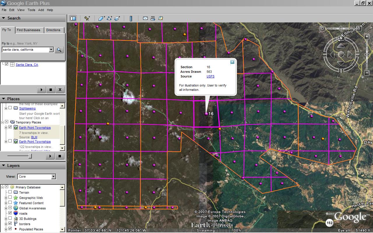
- The BLM townships are displayed on Google Earth. If you zoom in close enough, the sections are also displayed.
- Mouse-over the purple dots to find sections 16 and 17. We could stop here, but let's place the map onto Google Earth."BLM" townships, T10S R2E Section 16. Click for larger image.
- Normally, we get plat maps from a county assessor's office, title company, or the like.
- For this example, we can use the map above.
- Scroll up to the picture captioned Plat map. Click for larger image. Right-click the map. Click "Save As" on the pop-up menu.
- We are going to make an image overlay. The Google Earth User Guide has more information about image overlays.
- On the Google Earth menu at the top of the screen, click "Add" then "Image Overlay".
- On the window that pops-up, click the "Browse" button and get the plat map you saved.
- Shrink, stretch, and rotate the plat map to fit BLM sections 16 and 17 as best you can. It will not be perfect.
- Adjust the transparency so that you can see both the dark lines on the plat map and features on the underlying Google Earth imagery.Plat map aligned with Google Earth. Transparency is set to show the underlying satellite imagery. Transparency will be removed before the image overlay is saved. Click for larger image.
- Shrink, stretch, and rotate the plat map again, this time to fit the Google Earth imagery.
- Remove the transparency.
- Add a comment or two and save the image overlay.
- That's it!
22 comments:
wow!
This is a fantastic service. I used it recently to speed up progress on a project of mine.
It seems to be down at the moment, though. Hope it's not because your server has been crushed by usage.
Glad it is helping you.
We were off-line Wednesday and Thursday due to unrelated server problems at our hosting company. Thanks for your patience!
Very, very cool! I've been experimenting with something similar to plot gas well locations and over Texas Railroad Commission petroleum lease maps.
Hi Adam,
I have been experimenting with the Texas RRC data as well. Some sample data is posted at www.earthpoint.us/TexasLandSurvey.aspx
Let me know how it is goingfor you.
HI! i have to say that township and range on google earth is like a blessng to me. Thanks a lot for this fantastic service!
But i have a doubt. I've been trying to get connected to this, but its giving a fetching error!
Whats happening?
I am glad you find the site useful. Sorry for fetching errors. Our hosting company was off-line due to a networking problem. Overall though, I have been quite happy with the performance. I hope it is working for you as well. Please let me know if you have any problems or suggestions.
I like the overlay but I don't always need it. How do you get google earth to stop showing the plots?
Thanks
Riley
On the left side of the Google Earth screen is a section called "My Places", which gives you a folders view of the items you have downloaded to Google Earth. The townships are called "Earth Point Townships". Right-click "Earth Point Townships". From the pop-up menu, click "Delete". That should do it.
Is there a way to turn on the labels for the T/R and Sections. Doing a mouseover on the dots displays them but that doesn't work for printing the map with labels. Thanks!
This looks like a exactly what I need. Tried loading Google and had problems at first. Now it works. The problem I have is when I go the the "Township and Range" then clich on the search I want, It cannot find the file, and wants me to download a file reading software. Most of the ones recommend by ggogle search are Anti Virus prducts. I need a program to read the KLM. Have any suggestins?
Thanks
Click on "Townships & Ranges" Gives me a variet of searchs to do. I do the one that requres no signup to see if it works for me. When I click on the search botton it cannot find the file and suggest a google search. The search comes up with programs that claim to be KLM reading programs but ture out to be anti virus programs. Any suggestions on how to find one.
Thanks
Check to see if you have administrative rights to your PC.
Sometimes in an office environment with a computer support staff, the users do not have administrative rights to their computers. In this case, Google Earth will appear to load correctly, but in the end, the computer will not know how to open KML files. The solution is to have an IT person log into your computer as the administrator, and then reinstall Google Earth.
Another possibility is to check the computer's file associations. KML and KMZ files should be set to open with Google Earth.
Hope this helps. Please let me know if you need further assistance.
Anybody know how to outline a property in Google earth?
Hi Ian,
Glad to help. Please contact me anytime.
Bill Clark
Earth Point
bill.clark@earthpoint.us
208 860 6311
Any ideas on when Earth Point will be up and running again? Having Township/Range/Section info for a project I'm working on will be so helpful and I can't find the kmz file anywhere else!
The site was down this afternoon due to issues at our hosting company (Rackspace). I think everything is working now.
I don't know if anyone is still managing this blog, but I love the program. Unfortunately, I have done something and everytime I press the "Fly To On Google Earth", it creates a download for explorer but does not overlay onto google earth. Do you know I might be able to get this corrected? Thank you Robert Aina
Hello, There is a fix for this. https://www.earthpoint.us/help/topics/topic70.html
Scroll down to "Windows 10 Permanent Fix"
Please call anytime if I can help with this.
Bill Clark
208 860 6311
bill.clark@earthpoint.us
Hi not sure if you still manage this but the new Google Earth app (Mobile)doesn't seem to want to properly open the Earth point townships file (BLM GRID) anymore not sure if there is a work around or another app you recommend
I have just purchased a monthly subscription for Earth Point and I'm trying to get the Township and Range Grid to work by following the instructions at https://www.earthpoint.us/help/topics/trhti.html but when I open the file nothing happens. Can you help me?
Email me at bill.clark@earthpoint.us and we can get it working.
Post a Comment